This park was established in 1890. It contains the highest point in the United States – Mount Whitney which is 14,505 ft. The two parks are joined and Generals Highway connects them. Most of Kings Canyon was closed during our visit due to a sinkhole so we were not able to go into the canyon but could only view it from high points.

Moro Rock – a granite dome in the center of the park. In the 1930’s 351 steps were put in the rock so it could be hiked to the top. The elevation is 6,725 ft.

Great views and a little scary right on the top

But the views of the landscape in the distance made the climb worth it.


This tree was growing right out of the side of the rock

We think that is Mount Whitney behind the clouds


Tunnel Log fell in 1937 (can’t they get someone to clean this thing up by now?) – that was Jerry driving through. It is 275 feet tall and 21 feet in diameter!

Clara Barton – she’s the nurse who started the American Red Cross. This is just one of many things named in her honor. Kristi couldn’t pass up the nurse tree.

It is when you stand near them that the immensity is really seen

It looks like the rock was coming out of the tree but the tree grew around the rock

A light colored bear we saw in Round Meadow on the Big Trees Trail. Kristi spotted his back first moving in the grass and panicked, thinking it was a bobcat or something like that. It turned out to only be a bear – no worries!

This is how close Jerry was to the bear! He was minding his own business chomping on that grass. See video below.

He seemed dead but was definitely moving. There was a fawn running around nearby. We came back later and he was lying in a different place.

Many of the trees had burns like this. (Spoiler alert) It’s only going to get worse

The trees looked like they should be taller based on the size of their trunks, but it’s Redwood trees that grow very tall. See how these taper off quickly at the top?

We saw an amazing sunset off Generals Highway when leaving the park


The Fallen Monarch has been down over a century. It was used in the early 1900’s by construction crews to camp inside and the cavalry kept horses in the tree. We were able to walk completely through it.


Trees like these look like they started as one and grew into four trees, but really four little pine cone seeds started growing near each other and eventually merged at their bases


One of the leftover stumps from a time when they were cutting the trees because the wood was sought after

The Mark Twain Stump. This tree was cut down in 1891 (it took 13 days to cut it down!) and a slice of it sent to the American Museum of Natural History in NYC and is still there today. This has allowed people far from California to marvel at the immensity of sequoias. We had to climb a ladder just to get on the stump. See a fun video of Kristi below jogging on the stump.

2nd largest tree in the world

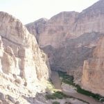
Kings Canyon from a lookout – this was as close as we could get due to road closures

Some of these trees looked like they should be dead, but they had branches growing off them

Very tiny itty bitty Jerry

Burn scars taken from in the tree

Proof that he was in the tree

Neat views from Congress Trail

On Congress Trail – The President Tree, named for Warren G. Harding in 1923. This is the 3rd largest tree in the world by volume and the oldest known living sequoia.

Part of the Congress Group – The “Senate” – a group of medium-sized sequoias

You can’t have a full Congress Group without the “House.” It’s probably obvious by now why we chose this trail, if you know us.


These two trees are making room for the Holy Spirit!

Another tree that looks like it shouldn’t still be growing anything. Jerry thought these looked like zombie trees

Congress trail goes through a fallen tree

After a lot of hiking and looking at trees we finally arrived at the biggest tree in the world – General Sherman!

The roads in this park were the craziest we’d been on through all 50 states. They had the sharpest hairpin curves and you really couldn’t go over 10 mph much of the time. It took SO long to drive through the park. See map below – this is how it looked constantly. We gained and lost about 7,000 thousand feet of elevation driving in and out.